

Ecology & Natural Resources
Flowing across the entirety of a single state, the James River crosses numerous ecological regions on its way from headwaters to Chesapeake. The information provided in this section outlines the various habitats and ecosystems that make our river so special. For more information on how to experience the James' beauty, follow the link to our 'Explore the River!' pages.
Physiography
In order to better understand how habitats change throughout the James River Watershed, one must first understand how the watershed is broken down into regions. Looking one step deeper than the ecological differences, one can see that the regions along the James change based on geological difference, more specifically physiographic ones. Over the course of time, the different rock types thoughout Virginia have shifted and faulted to create a picture of how the world changes. Although Virginia has five different physiographic regions, the James River Watershed only flows through four of them: Valley & Ridge, Blue Ridge, Piedmont, and Coastal Plain. Each supports various habitats and ecosystems conducive their environment.
Valley & Ridge: The headwaters of the James begin in the Valley & Ridge province, where the Jackson and Cowpasture rivers merge below Iron Gate to create the mighty James. The Valley & Ridge province consists of elongated parallel ridges and valleys that are underlain by folded Paleozoic sedimentary rock. The characteristic topography of this region, valleys and ridges, is the result of differential weathering of linear belts of rocks that have repeatedly erroded at different paces. The Shenandoah Valley, known as the Great Valley to the physiographic world, can be found in this province and boasts a plethora of carbonates, or layers of compact rock structures, from nearly 70 million years ago.
Blue Ridge: Following the eastward flow of the James, the next province encountered is the Blue Ridge. The oldest rocks in the Blue Ridge province are different


types of granite which date back over one billion years. These granite rocks that make up the Blue Ridge have been shoved over the rock layers of its neighbor to the west, the Valley & Ridge province. The rocks were moved to the northwest when (what today is) Africa and North America got sandwiched together, pushing the Blue Ridge on top of the Valley & Ridge along a fault line. By being deformed, older igneous and metamorphic rocks show that the continents crunched together and split apart many times during the Paleozoic Era.
Piedmont: As the mountains of the Blue Ridge turn into rolling foothills, the James makes its way into the Piedmont province, the largest physiographic province in Virginia. The Piedmont has gently rolling hills, deeply weathered bedrock, and very little solid rock at the surface. Most rocks at the surface become weathered in the humid climate and buried under a blanket of "rotten rock", called saprolite, several meters thick. The oldest rocks are ~1100 million years old, and can be found just west of Richmond in a place called the Goochland terrane. Rocks of the Goochland terrane are similar to rocks in the Blue Ridge province. The Piedmont also has a large abundance of slate, a profitable economic resource, that has documented collection and use dating back to pre-contact Native Americans.
Coastal Plain: The Falls of the James, in Richmond, mark both the head of navigation for the James and the move from Piedmont to the Coastal Plain province. The topography of the Coastal Plain is a terraced landscape, lined with resistant igneous and metamorphic rocks, that stair-steps down to the coast from Virginia's major rivers. The higher, older plains in the western part of the Coastal Plain are more dissected by stream erosion than the lower, younger terrace treads. This landscape was formed over the last few million years as sea level rose and fell in response to the repeated melting and growth of large continental glaciers. Thus, the flow of the James quickens as it begins its final descent into the Chesapeake Bay.
Habitats
The James River watershed stretches from the highlands in the west to the lowlands at the mouth of the river, passing through a variety of ecosystems and inhabited areas on its way to the Chesapeake Bay. These diverse habitats support Virginia's native flora and fauna, as well as migratory species passing through the region. Below are the major habitats within the watershed supporting the plant and animal life that make Virginia outdoorsmen revel in its beauty.
Pine Dominated Forest: One of the largest habitat types within the James River watershed is the pine dominated forest. They consist primarily of abandoned loblolly pine plantations or early successional loblolly pine forests that became established after agriculture ended. Loblolly pine forests are found from New Jersey to Florida and west to Texas, making it a critical habitat for species such as white tail deer, wild turkeys, and fox squirrels. The James River National Wildlife Refuge boasts approximately 2,600 acres of pine forest in the center of the refuge, which are being selectively thinned and prescriptively burned to improve forest health. This habitat populated much of the Valley & Ridge province, moving slightly into its neighbor to the east. Although these forests are dominated by Pines, many other trees make these forests richly diverse. These trees, as well as trees that line other habitats can be read about in our 'Flora' section below.
Moist Hardwood Forest: Another dominant habitat within the James River watershed is the moist hardwood forest. Represented by deciduous trees like white oak, American beech, and hickory, this forest supports a variety of game species and forest dwelling bird species. Vegetation is hardwood tree-dominated, although pine species can also be present. The shrub layer varies in density throughout hardwood forests. Many migratory birds time their arrival to the opening of the canopy in hardwood forests, which accounts for the greatest numbers of insects. These mixed forests also provide diverse habitat for amphibians and mammals in the region. These forests populate much of the Blue Ridge province, taking advantage of its softer soil and greater exposure to sunlight.
Floodplain Forests: Floodplain forests are composed of deciduous trees that thrive in moist soil, such as green ash, black gum, bald cypress, red maple, and cottonwood. These forests occur along major rivers and are subject to periodic flooding, erosion, and sediment deposition. The sediment that characterizes the soils of floodplain forests is predominantly fertile and acidic, allowing wetland trees to thrive. This habitat is essential to species that rely on both land and water environments, as well as protecting the shore from extreme weather events. Mature floodplain forests provide habitat for cavity nesters, detritivores, canopy-dwelling species, and neo-tropical migrants. Floodplain forests possess a high diversity of plant and animal species and ecological processes, making their conservation and management critical for regional biodiversity. Located mainly around the Fall Line and bordering up against both the Piedmont and Coastal Plain provinces, most refuges and management area in this region focus on habitat stabalization for floodplain forests.
Freshwater Marsh and Shrub Swamp: Freshwater marshes are permanently wet and dominated by non-woody vegetation. The James River tidal freshwater marshes are typically dominated by large grasses and floating or submerged aquatic vegetation, like salt hay, bulrushes, and cattails. Marshes are extremely productive, converting water, sunlight, and minerals to biomass at higher rates than drier ecosystems. Shrub swamps are freshwater wetlands that are in between true swamps and marshes because of moisture level. Shrub swamps are dominated by shrubs, with some tree cover as well. These marshes and swamps take advantage of the tidal waters of the Coastal Plain province, populating much of this region. The Great Dismal Swamp is one example of the biodiversity within these habitats.
Erosional Bluff: Sections of the James River consist of riverbanks that have eroded into steep cliffs of sand, silt, and clay. Bank erosion is a natural process, however human activity can greatly increase bank instability. The unique bank habitat provides shelter for burrowing animals, such as bank swallows and some invertebrates. These banks line the James, as well as many other rivers within the Chesapeake Bay Watershed, and are not limited to one physiographic province. While some herbaceous vegetation can be found along these eroded banks, it is often sparse.
Aquatic Habitats: Althogh the James River Watershed is filled with diverse land-based ecosytems, its aquatic habitats are equally as abundant. Running and still-water habitats support a variety of aquatic species and terrestrial species that rely on water to complete their lifecycles. Submerged aquatic vegetation in the James River include several species of pondweed, as well as macroalgae. Vegetation in aquatic habitats help filter polluted runoff and provide habitat for waterfowl and marine life. This vegetation and aquatic invertebrates are particularly sensitive to the health of the water, serving as useful indicators of the overall health of the James.

Pine Dominated Forest- Chesapeake Bay Program

Maple Trees in a mixed Hardwood Forest- Steven Severinghaus

Bald Cypress in a Floodplain Forest- Jenny Evans

Cattail growing above the surface of a Freshwater Marsh- Julie Falk
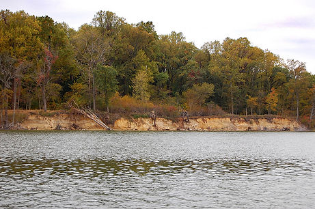
Erosinonal Bluff along the James River- Chesapeake Bay Program

A school of breeding fish utilizing their habitat- Gary Fleming
Fauna
The James River is home to many beautiful and intersting animal species. From the abundant to the endangered, the James has provided nourishment and shelter to a wide array of organisms for hundreds of years. Below, we will highlight some interesting fauna, as well as important animal patters that run through the watershed.
Atlantic Sturgeon: The Atlantic sturgeon (Acipenser oxyrinchus) is a member of the Acipenseridae family and is one of the oldest fish species in the world. Its range extends from New Brunswick, Canada to the eastern coast of Florida. Sturgeon and their relatives also comprise one of the more ancient families of fish and their fossils date back to the Cretaceous era. Their prehistoric-looking bodies are scaleless except for five rows of bony plates which run from head to tail. Four, fleshy, catfish-like whiskers protrude from beneath their snouts and are used by the sturgeon to stir up the insect larvae, snails and crayfish upon which they feed. Growing to the monstrous length

of 10 feet and weighing nearly 500 pounds, Atlantic sturgeon were once abundant in the James until dams were constructed on the river, prohibiting them from swimming upstream to their breeding grounds. The presence of these dams combined with silting, pollution, and over-fishing, has led to the near extinction of these once great fish. As rare and unusual as these fish may be, the sturgeon found in the James are unique even among sturgeon. The James River variety has been classified as a separate subspecies (Acipenser oxyrinchus kennicotti) and is found nowhere else in the world. Originally sought after for their delicate meat, sturgeon are now far more prized for their eggs which are unanimously considered by experts to be the highest grade caviar in the world. However, today, sturgeon are protected by law in Virginia and efforts are being made to help restore their dwindling numbers. The Virginia local goal is to restore the Atlantic sturgeon to the James River by using hatchery sturgeon. Fish ladders are being built into the dams to help mature fish reach their breeding grounds upstream. These measures, in conjunction with the ongoing efforts to clean up the bay, will hopefully set the stage for the return of these once great fish.
Tagging, Meaursing, and Releasing- James River Association
Fishing the James: Although from any ecological or geolgraphical measure, the James is one long, continous river, from a fisherman's eye, its two rivers broken up by the Falls of the James. Stand on the 14th Stretr Bridge in Richmond and look upstream and you’ll see a free-flowing, rocky, smallmouth bass river; look downstream and you’ll see a flatwater tidal smorgasbord in which all sorts of things swim. Upstream, above 14th, is dominated by a big predator and a premier gamefish, the flathead catfish and smallmouth bass, respectively. The go-to method for catching catfish is to swim a live bait in deep holes, while the bass are better angled using either a small, noisy, topwater lures near deep pools or soft plastics drifted along the bottom. The Downstream James, below the falls, is dominated by blue catfish and largemouth bass, the main predator and gamefish, respectively. Both fish are extremely abundant and just about any lure could bring you luck for either fish. Despite there being two "rivers," the James River's 400 miles have a single very best fishing location at a single time of the year: downtown Richmond in April. That's when and where the hickory shad, American Shad, white perch, and stripers congregate on their upstream spawning runs. On April weekends there are many, many boat and shoreline anglers casting lines – so, unless you like elbows, fish on a weekday. For the shad, throw tiny gold and silver spoons; for the white perch throw tiny (16th-ounce) white and chartreuse grubs; and use big white grubs and big topwaters for stripers (up to five pounds). For the jumbo stripers (up to 30 pounds) use fresh cut shad.


Flathead Catfish
Dept. of Game and Inland Fisheries
Smallmouth Bass
Dept. of Game and Inland Fisheries
Blue Catfish
Dept. of Game and Inland Fisheries
Largemouth Bass
Dept. of Game and Inland Fisheries
Hickory Shad
Dept. of Game and Inland Fisheries

Jamestown Island, VA


Dutch Gap and Henricus Historical Park; Chesterfield, VA
Natural Resources Glossary
Physiographic: geography that deals with the exterior physical features and changes of the earth— see Physical Geography
Paleozioc Era: a time of dramatic geological, climatic, and evolutionary change during the Phanerozoic Eon, spanning from 541 to 252.17 million years ago.
Cretaceous Era: a geologic period and system from 145 ± 4 to 66 million years ago
silting: sand, soil, mud, etc., that is carried by flowing water and that sinks to the bottom of a river, pond, etc.

Harry F. Byrd Bridge (Blue Ridge Parkway); north of Big Island, VA

Lynchburg Waterfront


CSX Railroad Bridge in Richmond, VA
Libby Hill Park, Church Hill Neighborhood; Richmond, VA
"The View That Named Richmond"
Experience the James: Viewsheds
Its impossible to measure the value of the beauty of the James River for all those who get to gaze upon it. The fall can be the best time to soak up a few great views of the James. Working our way downriver in no particular order of beauty, here are 10 memorable views of the James:

Upper James near Buchanan, VA

Balcony Falls along Rt. 501; southeast of Glascow, Virginia
Mixed Hardwood Forest- USFWS
Protecting Natural Communities
Throughout both the James River Watershed and Virginia as a whole, the biodiversity of the landscape has intrigued ecologists for decades. The five physiographic regions across the state provide different climates that, over the course of hundreds of years, have created unique and diverse ecological communities that support thousands of organisms. An ecological community is an assemblage of co-existing, interacting species, considered together with the physical environment and associated ecological processes, that usually recurs on the landscape. This present definition is restricted to natural communities, those which have experienced only minimal human alteration or have recovered from anthropogenic disturbance under mostly natural regimes of species interaction and disturbance. No portion of Virginia's landscape, however, has altogether escaped modern human impacts - direct or indirect - and only a few small, isolated habitats support communities essentially unchanged from their condition before European settlement. Since 1989, the Virginia Department of Conservation and Recreation has dedicated its natural heritage staff to the identification, protection, and stewardship of Virginia's biodiversity. To date, inventory has identified over 1800 conservation sites containing one or more rare species or communities. With over 45 employees dedicated to the preservation and stewardship of Virginia's natural heritage resources, the Division has available the skills of biologists, ecologists, zoologists, conservation planners, environmental resource managers, landscape architects, and data managers. To learn more about the DCR's work and the information on our local natural communities, click on the link about.
Watershed-Wide Tree Species:
The following is a list of the watershed's most common trees. These trees are not specific to one location, and can be found throughout the watershed:
-
American Beech
-
American Elm
-
American Sycamore
-
Black Cherry
-
Clack Walnut
-
Black Willow
-
Common Persimmon
-
Eastern Black Oak
-
Eastern Red Cedar
-
Flowering Dogwood
-
Green Ash
-
Red Mulberry
-
Slippery Elm
-
White Ash
-
Yellow Poplar
Other Tree Species:
The following is a list of the watershed's lesser common tree species. These trees can only be found growing in condensed area dispersed throughout the watershed:
-
Carolina Hemlock
-
Northern White Cedar
-
Longleaf Pine
-
Southern Live Oak
-
Atlantic White Cedar
-
Chinkapin Oak
-
American Basswood
-
Sweet Birch
-
Eastern Hemlock
-
Black Locust
-
Swamp White Oak
-
Cucumbertree Magnolia
-
Butternut
-
Eastern Cottonwood
-
Eastern White Pine
-
Winged Elm
-
Sweetbay Magnolia
-
Pitch Pine
-
Loblolly Pine
-
Virginia Pine

Mixed Hardwood Forest- USFWS

Flora
Across the United States, there are 12 different types of soil that dominate the landscape. Of these soil orders, Ultisols, make up much of the southeastern and eastern coastal regions of the country. Lining the coast, Ultisols were the first soils encountered by the settlers, as well as the soil used hundreds of years prior by the ancestors of the Powhatans. Ultisols are strongly leached, acid forest soils with relatively low native fertility. They are found primarily in humid temperate and tropical areas of the world, typically on older, stable landscapes. Because Ultisols have a low base saturation level of less than 35%, they are conducive too hardwood and pine forests and support vegetation in these habitats. They are known for their reddish-orange clay sub soil, resulting from the presence of iron oxides. Ultisols can be broken down into 5 suborders: Aquults, Humults, Udults, Ustults, and Xerults. Of these suborders, Udults are the most common, and make up much of the soil within the James River Watershed. Udults are known for their udic moisture regime, meaning they hold and disperse water evenly throughout the soil, making them conducive to humid climates. Nutirients present in the rooting zone can be found within the first few centimeters of soil. However, Udults is humus poor soil, which means

intense weathering has caused many of the main nutrients, Ca, Mg, and K, to leached down into the soil below the rooting zone, redering them ineffective in aiding plant growth. This leaching not only affects farmers today, but also plays a main factor in early settlers' struggles to create sustainable crop growth in settlments such as Jamestown and Roanoake. Without proper crop rotation and the use of fertilizer and lime, Udult soil cannot be continously farmed. However, by instituting proper farming techniques, as both today's farmers and early settlers have learned, this soil can be used to grow tobacco and harvestable vegetables.
Suborders of Ultisols in the United States- Natrual Resources Conservation Service
Cerulean Warbler
Audubon Society
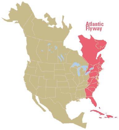
Atlantic Flyway: The Atlantic Flyway may be described as extending from the offshore waters of the Atlantic Coast west to the Allegheny Mountains where, curving northwestward across northern West Virginia and northeastern Ohio, it continues in that direction across the prairie provinces of Canada and the Northwest Territories to the Arctic Coast of Alaska. The flyway embraces several primary migration routes and many more that are important as tributaries, some of the latter being branches from primary routes of other flyways. The Atlantic Flyway is home to a wide variety of ecosystems—and more than a third of the human population of the United States. Many organizations, such as the Audubon Society, have made it their mission to protect the migratory birds and their habitats from human activity and the threat of sea-level rise. Shorebird monitoring programs from New York to the Bahamas ensure beach-nesting species, including the Piping Plover and American Oystercatcher, have safe places to rear their young. Furthermore, n eastern shrublands and woods, the Cerulean Warbler and Woodcock benefit from habitat restoration efforts and partnerships between organizations and private landowners to increase sustainable land management. All in all, organizations up and down the eastern seaboard are working together to make the entire Atlantic Flyway a better place for birds and people.
American Woodcock: While it may be difficult to spot an American woodcock (Scolopax minor), witnessing this bird’s curious behavior is worth the search. The woodcock, also known as the Timberdoodle, travels along the forest floor, using its long bill to probe the ground for earthworms. Its mottled brown tones and small round bodies allow it to camouflage well with the forest floor and in grassy fields. The woodcock’s eyes have also become well-adapted to its behavior, making it possible for the bird to keep an eye out for predators above while simultaneously probing the ground for worms. While the American woodcock maintains healthy population numbers in many regions, there have been considerable declines in New England, parts of the Mid-Atlantic, and Minnesota. The woodcock lives in young (early successional) forests; however much of its former range has become mature forest or has been converted for development. In addition, because woodcocks forage on the forest floor and rely heavily on earthworms, they are particularly susceptible to contaminants in the soil. Today, the Woodcock Task Force, a group of federal and state wildlife agencies and other organizations, are working with public and private landowners to create habitat for this iconic species. View the American Woodcock Conservation Plan here.
Cerulean Warbler: Whether an avid bird watcher or just out for a walk in the woods, you would be very lucky to catch a glimpse of the beautiful sky-blue Cerulean warbler (Setophaga cerulean) in the treetops. This warbler prefers to nest and forage higher in the deciduous canopy than other warblers, making it very difficult to spot against the blue of the sky. The Cerulean warbler migrates from tall deciduous hardwood trees in the warmer months, to tropical evergreen forests in the winter. They primarily rely on insects for food, but will consume plant material and nectar in the winter, as well. This small songbird is important to the health of its ecosystem because it feeds on insects that are often considered forest pests, like cankerworms, caterpillars, and moths. Unfortunately, the Cerulean warbler’s habitat and population size have been rapidly declining. The species is listed as vulnerable and is of highest concern for conservation in the eastern United States. Loss of its tropical wintering habitat and breeding grounds to farmlands and residential development is making it increasingly difficult for this beautiful bird to successfully reproduce. In Virginia, large tracts of deciduous hardwood trees are disappearing for residential and commercial development and roadways. This development further fragments the landscape, making it difficult for the cerulean warbler to find suitable protected habitat. One thing that the Cerulean Warbler and American Woodcock have in common is that they follow the same migratory patter along the Eastern Seaboard, known as the Atlantic Flyway.


American Woodcock
Audubon Society
Oysters in the Bay: Generations of Americans have been able to enjoy our nation's abundance of fresh oysters. Farms and the wild alike have been able to yield enough oysters to fill demand. However, this image might not be as readily available for future Americans. Ocean acidification, pollution and oil spills have caused oyster production to fall in recent years. Globally, oyster populations are in serious trouble, with more than 90 percent of the world’s oyster reefs having been lost in the past century, according to a 2011 study. But there is one oyster that can claim it is better off today than it was a decade or two ago. It is Crassostrea virginica, of the Chesapeake Bay. Last year, Maryland and Virginia reported their best oyster harvests in three decades, gathering a combined 900,000 bushels. And that number doesn’t include the oysters in both states that are raised in floats and cages, which is rapidly becoming a multi-million-dollar business. For decades, this oyster was written off, due to the polluted state of many

of the Bay's tributaries. However, thanks to a brilliant oyster geneticist, improved state and federal management, the expansion of private hatchery operations, the cleanup of the Chesapeake Bay, and a little bit of help from Mother Nature in the form of average rain years and excellent reproductive oyster classes this breed is making a come back. A vital part of the Chesapeake’s ecosystem, oysters can filter 50 gallons of water a day, create marine habitat, encourage bay grasses, and provide excellent homes for organisms at the bottom of the food chain. When they are farmed, oysters are a net benefit to the waters where they live, unlike other farm-raised species such as fin-fish, which pollute waters with fecal material.
The Virginia Oyster Trail
The Virginia Oyster Trail is a visitor-directed experiential “journey of discovery” program featuring Virginia’s Oyster regions; with unique waterman/aqua-artisan sites, inviting community narratives and many hospitality, creative, culinary, cultural and activity points of interest to be found along the way. Fundamental to its visitor experience attributes, the program focuses on increasing awareness of the benefits Virginia Oysters have on local economies; with emphasis on community development, environmental stewardship,entrepreneurial growth, health attributes and the cultural integration of Virginia’s distinctive aquaculture way of life. On its website, users can find local oyster resturants and oyster-based cultural activities throughout the trail's 8 regions. In recent years, the VA Oyster Trail has launched its Oysters Year 'Round initiative. Normally, oysters could only be eaten in months with an -r due to oysters' spawning cycle. However, through this program, the VA Oyster Trail is empowering oyster farms and cage raised oysters in order to provide the Virginia community with a community favorite 365 days-a-year.

Chesapeake Bay Foundation