

History and Culture
The name "America's Founding River" is not thrown around lightly. The James River has a storied history that captures the lives of many different people. From the tribes of Algonquin peoples that inhabited the region for hundreds of year to George Washington and the Kawaha Canal, the James breathes history and culture. Below you will find brief introductions to many culutral aspects of the James River. For more information on the river itself, click here.
Origins of Richmond
Prior to settlers establishing their place in Virginia history, the Powhatan tribe ruled the region. The strategic location of the Falls of the James made the area around modern-day Richmond the most important political, military and economic hub for the tribe. Until the arrival of the English in 1609, Parahunt, the chief of the Powhatan tribe, had his main capital on a high hill overlooking the falls of the James. The Powhatan tribe was one of the main tribes in the confederacy of the same name, and the river, in their language, was likewise known as the Powhatan. The village where Richmond is now also went by the name of Powhatan as well as Shocquohocan or Shockoe.
Reconstructions of early colonial Powhatan population from colonial references indicate that approximately 13,000 Powhatans resided in 6,500 square miles of the Virginia Coastal Plain. Contrary to popular belief, the story of settlers and the Powhatans does not begin to intertwine in 1607. Intermittent encounters between Europeans and Virginia Indians occurred throughout all of the sixteenth-century, with contact after 1586 generally ending up violently. Thus, uneasy early encounters set the scene for John Smith and the first settlers arrival in Powhatan territoy.
Two weeks after landing at Jamestown in 1607, a party of two dozen English under Captain Christopher Newport set out by pinnace to explore the Upper James. They learned of the existence of this important site from the natives they encountered on the way. At the time, the Native population of Tidewater Virginia was under the sway of Wahunsonacock or Powhatan, a paramount chief who governed his people in a manner Captain John Smith described as monarchical. Captain John Smith observed that Indian men spent most of their time hunting, fishing and engaging in wars, while the women and children made mats, baskets, and pottery and raised the crops upon which their villages depended. He described the Powhatans as generally tall and straight, with black hair and dusky complexions, and noted that the men rarely had beards. He said that the Natives were exceptionally strong and agile and tolerated even the worst weather. But there were many

subtle and more important differences between the Indians and the Europeans. The Powhatans considered land merely a part of the earth, like the sky, water and the air, and therefore open to all for subsistence. Thus, the European concept of owning land was foreign to them. However, despite these vast differences, the fist encounter between Newport and the Powhatans was successful. Returning downriver, the Captain erected on one of the islands, a cross reading Jacobus Rex, 1607, declaring the country to be the possession of James I of England; however, he told his guide, Navirans, that the cross signified an alliance between himself and the chief of Powhatan.

Following this, the English settlers and the Powhatans remained relatively peaceful for the next few decades. Despite a few futile and midly violent attempts to settle closer to the Falls, the settlers of Jamestown remained unintrusive allies to the Powhatans during their bouts with their rivals residing west of the Falls, the Monacans, until the Indian Massacre of 1622. Following the Second Anglo-Powhatan War of 1644-45, the Powhatan tribes signed a peace treaty in 1646 ceding the settlers all territory below the Fall Line, from the Blackwater River to the York River. At this time, the colony built Fort Charles at the falls of the James, near where the legal frontier was for over half a century. After two years, the site of Fort Charles was relocated to Manastoh on the South Side of the river (later known as Manchester), where the ground was considered slightly more fertile. In 1673, William Byrd I was granted lands on the James River that included the area around Falls that would become Richmond and

already included small settlements. Byrd was a well-connected Indian trader in the area and established a fort on the site. William Byrd II inherited his father's land in 1704 and expanded the families wealth as a planter. In 1737, Byrd II commissioned Major William Mayo to lay out the original town grid. Byrd named the city "Richmond" after the English town of Richmond near (and now part of) London, because the view of the James River was strikingly similar to the view of the River Thames from Richmond Hill in England, where he had spent time during his youth. The settlement was laid out in April 1737, and was incorporated as a town in 1742.
The pre-contact era for the Powhatan Indians was one of great affluence and prosperity. Chief Powhatan brought peace to over eleven rival tribes, creating a structured cheifdom unlike any other Native American hierarchy. However, upon meeting the settlers in the early 17th century, things began to turn for the worse. For the next three hundred years, Chief Powhatans descendants faced many hardships on behalf of the Virginian people. From being forced off their land soon after meeting John Smith and his travelers to decades of racial discrimination in the 20th century through the Racial Integrity Act, the Powhatan chiefdom boke apart under the pressures of their New World counterparts. Yet, these Native Americans, now split into many tribes, have not turneed away from their sorrowed history but embrace these trials and tribulations through various annual cultural events.
Richmond's Driving Forces: Slavery & Tobacco
Slave Trade
Tobacco Kingdom
Early trade grew rapidly, primarily in the agriculture sector, but also in the slave trade. Slaves were imported from Africa to Richmond's Manchester docks, and were bought and sold at the same market. Shockoe Bottom was a center for slave trading. Yet, most of Richmond's slave trade was not found paraded around the city's main strips, but in slightly marginal spaces, adjoining cooperages, wagon repair establishments, and in the basements of fine hotels. While on the surface, especially in the legislative and political landscapes, the trade itself was not as openly celebrated as it was in the state's other Southern bretheren. Most often, white Virginians did not mention enslaved people at all, and when they did, they were mentioned in ledgers. However, it is believed that between 1800–1865, 300,000 slaves were sent from Shockoe Bottom to work in the deep south. All in all, the words of Frederic Bancroft summarize Richmond's slave trade perfectly when he states, "In the Chesapeake area more than anywhere to the northward, the shortage of labor and the abudance of land...placed a premium on involuntary labor. The cultivation of tobacco in the region required labor which was cheap but not temporary, mobile but not independent, and tireless rather than skilled." The city’s pivotal location in proximity to the agricultural fields of Tidewater and Southside Virginia, and North Carolina, the natural power source provided by the falls on the James River, and its accessibility as a shipping port and later as a railroad hub made Richmond an ideal place for one of slavery's many meccas in the Old South.
The history of tobacco in Richmond is almost as old as the settlement, itself. Sir John Rolfe first began experimenting with tobacco planting in early 17th century Jamestown. When the tobacco plants began depleting the soil in this region, planters began moving westward towards the fertile ground of the James near Richmond. However, by the early 18th century, the population of the area was still below 200, making it difficult for farmers to find workers to tend to the laboroius crops. In 1730, the Virginia House of Burgesses passed the Warehouse Act, which required inspectors to grade tobacco at 40 different locations. This led to much development at the Falls of the James. Very quickly, tobacco formed the basis of the colony's economy: it was used to purchase the indentured servants and slaves to cultivate it, to pay local taxes and tithes, and to buy manufactured goods from England. Promissory notes payable in tobacco were even used as currency, with the cost of almost every commodity, from servants to wives, given in pounds of tobacco. When Virginians first began exporting tobacco, they relied on building personal relationships with English merchants to whom they sold their wares. This allowed planters to receive payment immediately instead of waiting for the tobacco to be sold in Europe. But as tobacco prices fell in the 1680s and 1690s and the market became less stable, it was more economical for planters to ship at their own risk to England, where a commission agent would, for a fee of 2.5 percent, store the tobacco, pay all duties and fees, sell it, and use the profits as his client directed. By 1730 approximately 40 percent of Chesapeake tobacco was being shipped by the consignment system. Although tobacco farming nearly created the agriculutral power that was the pre-Revolutionary South, the war nearly destroyed tobacco practices of the era. According to the historian Melvin Herndon, the total crop output for the entire period of the war, 1776–1782, was no larger than the total yield of one year of pre-Revolutionary production.


Tobacco Row, circa. 2002
Traversing the Rapids: The Development of the Kanawha Canal
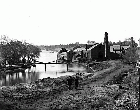
Although much of the city of Richmond was burned down by the British during the Revolutionary War, the trade center of the South quickly reestablished itself during the post-war era. By 1782, the city was once again fully functional, which allowed the city's agricultural endeavors to reach near pre-revolutionary peaks. However, the same geographic feature that made Richmond so appealing to early settlers also prevented Richmond's traders from reaching full operating capacity: the Falls of the James. However, future President George Washington, Virginia resident and Tidewater man, strongly advocated the cause of developing the navigation of the James River, with the ultimate hope of connecting the headwaters of the eastward-flowing James with the westward-flowing Kanawha Rivers. Washington believed that this connection would then open up access to the resources of the American West via the Ohio and Mississippi Rivers. Thus, The James River Company was chartered in 1785 with George Washington serving as

honorary President for the purpose of improving navigation on the James from Richmond to Botetourt County, a distance of approximately 200 miles. Much of the canal was surveyed and planned by Washington himself in his younger years before his presidency. The digging of the beginnings of a towpath made it possible for cargo-bearing barges to navigate up the canal and beyond the rapids of the James River where it flows past downtown Richmond. Construction of the Great Basin by the turn of the 18th century and completion of the Tidewater Connection in 1822 allowed larger boats to enter the city below the falls, further increasing Richmond's rapid development as a trade epicenter. By 1840, construction of the canal was complete from Richmond to Lynchburg. A series of wooden locks, most dating from the 1840s, permitted access to the upper James River, the focus of subsequent developments. By 1851, the canal system extended 197 miles westward, terminating at what would be its final destination, the town of Buchanan in Botetourt County. The building of the “great lock” next to the present-day intersection of Dock and Pear Streets between 1850 and 1854 connected the James River with the Richmond Dock completing the James River and Kanawha Canal system. The location is now a small city park called the Great Ship Lock Park. The 1850s were the heyday of the James River and Kanawha Canal, the time canal traffic was at its busiest. Nearly 200 boats passed through on a regular basis, with barges bringing raw materials like tobacco and wheat from western Virginia and returning with other products from the city. Passenger boats, called packets, made up only a small percentage of traffic on the canal. They typically carried as many as 40 people and, with draft animals pulling the boats from the adjacent towpath, took approximately 33 hours to reach Lynchburg.


Shockoe Valley Triple Crossing
Virginia Commonwealth University Libraries
Railroads Role in Richmond
Throughout Richmond's history, transportation technology was one of the fatest growing industry, spurred by the need to ship surplus tobacco outside of the region. Since people do not eat tobacco, the supply vastly exceeded local demand for smoking/chewing; thus, the need to move bulky, heavy tobacco from farm fields to Europe and other parts of America became almost as important to farmers as proper weather and soil conditions. Originally, roads were developed so people could walk or ride from farms to churches and the county courthouse, but until settlement began to move upstream past the Fall Line in the 1720's, there was little investment in building land-based transportation. Once Virginians moved into the Piedmont, agricultural freight was hauled in wagons on dirt roads to Tidewater ports. Turnpikes were chartered, starting with the Little River Turnpike in 1795. Stockholders funded road improvements/bridges and ensured regular maintenance, in exchange for tolls. However, shipping farm products in bulk via dirt roads was expensive, so new technology was explored to improve farm-to-market transportation. Canals, such as the aforementioned Kanawha, became the primary source of land-based transportation, yet farmers continuously hoped to reach areas away from navigable rivers. The new technology of wood-burning locomotives and iron rails broke this barrier wide open, stimulating cities on the Fall Line to build low-cost railroad connections to inland "backcountry" or "hinterland" areas. Virginia's railroads were designed originally to transport farm products to specific ports, mimicking the farm-to-market pattern of turnpikes. Local stockholders constructed competing rail lines to develope trade to competing Virginia cities. Richmond-oriented investors built the Virginia Central and other lines to draw business to their port, particularly in competition with Norfolk. Petersburg investors funded the South Side Railroad, which drew trade away from Richmond. Completion of that railroad to Lynchburg forced the James River and Kanawha Canal to reduce its tolls. Even in Virginia cities served by two or more railroads, the separate tracks were not connected with each other. Each railroad built its terminal in a separate location, demonstrating its intent to send trade to a specific city. If the railroad lines had been designed to provide transportation through the city for a more-distant destination, tracks would have been joined and a common gauge would have been adopted. Instead, some Virginia railroads built tracks with a "broad" 5-foot distance between the rails while others used the "standard" gauge of 4 feet, 8-1/2 inches. This was exactly the case in Richmond, which by 1861 had five lines fanning out in different directions throughout the city. Though taxpayers financed 40-60% of the cost for most railroads, the lines were located to serve as tools for local economic development and not for the entire state. Refusing to link rail lines was inefficient, but each railroad was independent. Individual cities, like Richmond, benefitted from carting and warehousing the freight, and from passengers who bought meals or stayed overnight. On top of increasing importation/exportation in the city, making it an even greater financial powerhouse in the South, Richmond's plethora of railroads was also one of the deciding factors in naming it the capital of the Confederacy before the Civil War.
The Confederate Capital

Library of Congress, Geography and Map Division
Originally, like many other southern cities, Richmond opposed secession on economic grounds. After all, Richmond's merchants supplied Northern markets with tobacco; its flour-milling firms dominated trade with South America; and Tredegar ironworks produced railroad iron and ordnance for the federal government as well as state governments in the North. Within its political sphere, two competing parties fought to get their points across: secessionists and cooperationists. While secessionists clearly vied for seperation from the Union, cooperationists did not want actual cooperation with the North; rather, they resolved to wait for the North to act aggressively first. Amidst this political stalemate, Abraham Lincoln's election and subsequent decision to fortify Fort Sumter with troops was all any politican needed to make up his mind. On April 17, 1861, the Virginia Convention, which had been convened in Richmond since February, finally voted to secede, a decision ratified by a statewide referendum on May 23.
Within days, talks of moving the Confederate capital, then in Montgomery, Alabama, to Richmond spread like wildfire. The move made sense for symbolic, economic, and military reasons. From its inception, Richmond bore the imprimatur of revolution: Patrick Henry thundered "Give me liberty or give me death!" at Saint John's Church, and Thomas Jefferson
designed the Capitol building. On a more practical level, Richmond was the South's leading industrial city, an important transportation hub, and source of agricultural resources. Virginia, meanwhile, was the richest in natural resources and most populous state in the South and boasted the region's largest rail network, as well as a mixed agricultural economy. Although Richmond's proximity to Washington, D.C., was hazardous strategically, Virginia's topography—the Appalachian Mountains and rivers, such as the James and Rappahannock, that flowed east to west—served as a natural defense against invasion. However the resource in Richmond with the most appeal to Confederate authorities was Tredegar Ironworks, the leading railroad steel manufacturer in the region and, possibly, the South. They saw Tredegar as the cornerstone to fortifying Confederate strongholds, as well as arming and equipping the Confederate militia for the entire length of the war.
Throughout the Civil War, the Confederate government relied on Tredegar and a number of smaller local firms to manufacture everything from heavy ordnance and iron cladding for naval vessels to buttons and bullets. In 1864, Ordnance Bureau chief Josiah Gorgas noted that the Confederacy had become self-sufficient in the production of war matériel. This was remarkable considering that in 1860, the future states of the Confederacy had accounted for only 16 percent of the nation's capital invested in manufacturing. Such an economic turnaround was largely due to the output of Richmond's manufactories and especially the Tredegar ironworks. Further, despite being the political and industiral home of the Confederacy, Richmond was a center of rail, military hospitals, and prisoner-of-war camps and prisons, including Belle Isle and Libby Prison.
Library of Congress, Prints and Photographs Division

The Chickahominy tribe is Virginia's largest descendant of the Powhatan chiefdom, with approximately one thousand members. It was recognized by the state of Virginia in 1983.
Their current land holdings includes a 25,000-acre enclave that has:
-
a 500-acre tract that holds what once was known as Samaria Indian School, now known as Charles City Primary School.
-
a tribal center for meeting and recreation.
-
a 225-acre tract set aside for younger tribe members who wish to live and raise their families within the enclave.
The Chickahominys of today celebrate their history on a daily basis through practicing the traditions and rituals of their ancestors. Passed down through both written and oral traditions, these practices emphasis that each member of The Chickahominy tribe is Virginia's largest descendant of the
Powhatan chiefdom, with approximately one thousand members. It was recognized by the state of Virginia in 1983.
Their current land holdings includes a 25,000-acre enclave that has:
-
a 500-acre tract that holds what once was known as Samaria Indian School, now known as Charles City Primary School.
-
a tribal center for meeting and recreation.
-
a 225-acre tract set aside for younger tribe members who wish to live and raise their families within the enclave.
The Chickahominys of today celebrate their history on a daily basis through practicing the traditions and rituals of their ancestors. Passed down through both written and oral traditions, these practices emphasis that each member of
Property of the Chickahominy Tribe of Virginia
Before 1607
In the pre-contact era, the Powhatan tribe, named after their chief and the river that became the James, dominated the area around the fall line (modern day Richmond). The Monacan tribe populated much of Central Virginia.
Led by Captain John Smith, early English settlers established a colony at Jamestown. The English chose Jamestown Island, 60 miles from the sea, because it could be defended against the Spanish and its deep water allowed sailing ships near shore.
1607- Jamestown
1612-Tobacco
Sir John Rolfe introduced tobacco as a cash crop to early English settlers. This new, fast-moving industry, helped spur westward settlement for the next 200 years.
As the population of westward settlements increases, the colony capital is moved to Richmond. However, this same year, Benedict Arnold leads a British force up the James to march on and plunder Richmond during the Revoluntionary War.
1780- Revolution
The James River played a crucial role for both sides during the Civil War. The North hoped to cut off supplies to the South by barricading the river. Likewise, the South believed the North would use the river as a pathway to capturing the Confederate capital of Richmond.
1861-65 - Civil War
By the late 1800s, Richmond was at the forefront of railroad expanision in America. By 1861, there were five seperate railways leading in and out of the city from all major directions. These lines helped promote Richmond to a leading agricultural power in the post-Civil War South.
Late 1800s- Railroads
In August 1969, Hurricane Camille triggered the worst flash flood disaster in 20th century Virginia. During the storm, the James River set new flood records with water cresting to 28 feet in Richmond and 41 feet in Columbia. Over 100 people died and over 100 bridges were washed away.
1969- Hurricane Camille
Present Day
Although its history has not always been bright and clean, the present day James is in its best state in over 40 years. Bald eagles and great blue heron have returned to nest along its shores and the Atlantic sturgeon, once thought to be extinct, are spawning in its waters once again.